
DARKE COUNTY — The National Weather Service (NWS) in Wilmington, Ohio has confirmed that an EF0 tornado touched down 3 miles south of Gettysburg Saturday night.
The tornado is estimated to have hit at 6:16 p.m. with a maximum estimated wind speed of 76 miles per hour. The path of the tornado was 50 yards wide and 4 miles long.
According to the NSW, the tornado touched down in a corn field north of Neff Road and continued northeast across the 5200 block of Gettysburg-Pitsburg Road, leaving a home untouched but knocking down a rotted tree just behind it.
A barn behind the home sustained significant damage, losing a quarter of its roof and the entire overhang attached to the back of the barn. The sliding front door of the barn was also flipped up over the roof.
A small tractor trailer parked behind the barn was flipped onto its side and was damaged by flying debris. Debris from the barn was found strewn about 200 yards east into a soybean field behind the farm. A few large branches were found snapped off a tree behind the barn.
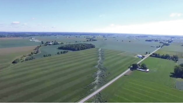
Drone footage shared by the Darke County Sheriff’s Office showed a continuous tornado path through soybean and corn fields stretching a few miles northeast of the initial touchdown location. The drone footage can be watched on You Tube at https://www.youtube.com/watch?v=E4RE9y4GpIQ and https://www.youtube.com/watch?v=m0m2oNEvRE4
As the tornado tracked northeast from the damaged farm, it passed just about 300 feet north of a residence on Yount Road.
Downstream crop damage revealed the tornado crossed Byreley Road, Red River-West Grove Road, and Grise Road. The tornado path ended in a soybean field just east of the Darke/Miami county line after crossing State Route 721.
There were no injuries.